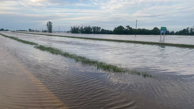
Southern Manitoba saw a wild night of storms, with monsoon-like downpours, one confirmed tornado and vehicles abandoned on flooded roads.
Stonewall was hit the hardest by the rain. The town, just north of Winnipeg, had more than 255 millimetres reported as of 9:30 a.m. Wednesday, according to the Community Collaborative Rain, Hail and Snow Network (CoCoRaHS), from which Environment and Climate Change Canada gathers reports.
Petersfield and Clandeboye, both northeast of Stonewall, were soaked with 229 millimetres and 220 millimetres, respectively. Woodlands, northwest of Stonewall, got more than 121 millimetres.
In an online update, the Town of Stonewall said its sewage system is running at or near capacity. It urged residents to limit unnecessary water use — laundry, dishwashing and long showers — over the next 24 to 48 hours to allow the system to recover.

All schools in the Interlake School Division, which stretches from just north of Winnipeg up to Teulon, east to Stony Mountain and west to Woodlands, are closed Wednesday.
Several are flooded, a CBC reporter was told.
Winnipeg was drenched with 117 millimetres of rain, recorded at The Forks. Inundated basements, impassable streets and engulfed underpasses were reported around the city.
Many weather stations in the province reported over 50 millimetres, Environment Canada said.
The intense weather was spread across the province’s south, with wind gusts clocked at 130 km/h in the Deloraine area, near the Saskatchewan border.

Wind gusts in excess of 100 km/h were reported in several other places, with Brandon hitting 100 km/h and Winnipeg clocking a peak of 94 km/h.
There was also hail, ranging from the size of nickels to tennis balls in parts of Winnipeg, while some rural areas saw hailstones the size of baseballs.
The one tornado confirmed as of Wednesday morning touched down in the Ste. Anne area, southeast of Winnipeg, but many others are being investigated in the region, including possible tornadoes in Otterburne, just south of the city, as well as through much of the Red River Valley, east of Morris, and in the Parklands area in western Manitoba, Environment Canada says.
Numerous funnel clouds were also reported, the weather agency said.
“There was lots of rotation with the storm, and it got down pretty low,” said Environment Canada meteorologist Kyle McAuley.
The weather system started south of Emerson in the U.S. and moved north through Manitoba.

Although no possible tornado sightings were reported in Winnipeg, the city was under threat, McAuley said.
“We were definitely at risk a few times … [due to] thunderstorms that were rotating pretty violently,” he said.
“This is by far the closest day, within a few years that I could recall, of a tornado hitting Winnipeg or being near Winnipeg.”
Ste. Anne also saw what was likely a supercell, an ominous tower of rotating cloud that had the potential to turn into a major twister.

“It was definitely close,” McAuley said. “Luckily there doesn’t seem to be too much damage reports yet, which is a good thing, and no life has been taken. Hopefully that’s [the news that is] going to continue throughout the day.”
Power outages
Manitoba Hydro said 1,000 separate power outages are affecting 32,000 customers in the southern half of the province, a spokesperson said Wednesday morning.
The Crown corporation is bringing in additional staff to relieve firefighters and police in Winnipeg who are guarding scenes where live wires have fallen, it said in a news release.
“Those storms packed quite a punch and they did considerable damage to power lines and poles. We had a lot of reports also of loud bangs and flashes, indicating that there’s transformer boxes and other such equipment involved,” Hydro spokesperson Peter Chura told CBC News.
The outages are scattered over a wide area, which means it will take some time to get to all of the repairs, he said.

“Last night, the priority was safety, of course. That lightning just seemed to go on and on, and as long as there’s lightning around, our crews can’t work on power lines and poles,” Chura said.
“So we’re just … starting to get to work on many of them now and getting a better idea of what the extent of damage is and what the restoration times are going to be. But for many of them, they are going to be lengthy.”
The rain was not as bad in western Manitoba, where severe flooding has impacted the municipalities of Swan Valley West and Minitonas-Bowsman since Sunday.
“Luckily they didn’t get too much. They were kind of saved,” McAuley said. “They maybe only got … about eight or nine mm, which is still a good amount of rain but not like what we saw around Winnipeg.”
It would appear the most severe weather is over for Manitoba, which has been belted since the beginning of the week, but the storms aren’t quite done yet, McAuley said.
There are probably going to be thunderstorm watches and warnings issued Wednesday in the southeast, “but maybe only a yellow alert, unlike yesterday, which was a full on red and well warranted.”