Listen to this article
Estimated 3 minutes
The audio version of this article is generated by AI-based technology. Mispronunciations can occur. We are working with our partners to continually review and improve the results.
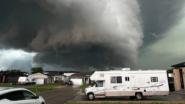
A tornado warning issued for Winnipeg has been lifted — one of a series of warnings that covered southern Manitoba on Tuesday afternoon and evening as severe thunderstorms swept across the province.
Forecasters are tracking a severe thunderstorm possibly producing a tornado, Environment and Climate Change Canada says. Damaging winds, large hail and heavy rains are also possible.
Environment Canada issued the warning for the areas of Transcona, St. Boniface, East Kildonan and East St. Paul at 6:49 p.m. It was lifted after 7 p.m., the weather agency’s online map showed.
The situation remains “very dangerous and potentially life-threatening” as the tornado warning now covers areas just east of Winnipeg, including Beausejour, Dugald and Oakbank, the warning says.
“That storm has essentially just been building itself as it slowly moves to the northeast,” Alysa Pederson, warning preparedness meteorologist with Environment and Climate Change Canada, told CBC News in an interview shortly after 7 p.m.
Another tornado warning was issued in the province’s southwest around 7:30 p.m., with the communities of Oakburn, Strathclair and Menzie in the path of a severe thunderstorm that is possibly producing a tornado, that warning says.
Pederson says the weather agency received two reports of tornadoes Tuesday, one near the town of Morris and another in the St. Anne area, but they are unconfirmed.

The warnings began just after 4 p.m. for the communities of Grunthal, St. Malo and St-Pierre-Jolys.
Those warnings were replaced by tornado warnings for Ste. Anne and La Coulee at 5:24 p.m.
Most of southern Manitoba is also under an orange tornado watch as a “large linear thunderstorm complex” is expected to move in from Saskatchewan on Tuesday evening, the weather agency says.
The watch, issued just before 2 p.m., covered most of the province’s southwestern corner, stretching up to the western shore of Lake Manitoba and part of the Interlake region. It also included the cities of Brandon, Winnipeg, Portage la Prairie, Steinbach, Morden and Winkler.

Severe thunderstorms that could produce tornadoes are possible in the weather conditions in those areas, the weather agency said. Strong winds, large hail and heavy rain are also possible.
Forecasters predicted a developing frontal system would move into southern Manitoba on Tuesday afternoon, bringing in an unstable air mass “ripe for the development” of severe thunderstorms, Environment Canada says.
The thunderstorms are expected to begin around 4 p.m. to 5 p.m. over southwestern Manitoba and parts of southeastern Saskatchewan, with the first storms “being discrete” before growing into a “large linear thunderstorm complex” that will move eastward over southwestern Manitoba Tuesday evening, the watch said.
The development of smaller thunderstorms are also possible over the Red River Valley later Tuesday afternoon, the watch said.
Large hail will be the primary threat early on in the storms before they present a “widespread wind threat” early Tuesday evening, the watch said.

Manitoba is one of the country’s most tornado-prone provinces in the spring and summer months.
Watch to learn what to do to stay safe when a tornado warning is issued.