| Pune News")


Modelling by the CSIRO shows that even the installation of 10 upstream “detention” basins would not have saved Lismore during the record-breaking floods of 2022.
The organisation has been running scenarios through its super-computer in Canberra to test how flooding would be reduced in northern NSW towns devastated by the 2022 floods.
Loading…
They include construction of up to 10 “detentions” to hold water in upstream creeks during times of flood, and a canal cut through farmland to create a second outlet for the Richmond River near the coast.
“Right from day one, when they were asking me, ‘can I flood-proof the region?’ my answer always is, ‘nobody can’,” CSIRO project lead Jai Vaze said.
“The aim is to reduce the impact of flood.”
The CSIRO tested two ‘bundles’ of mitigation options against flood data from 2008, 2017 and 2022.
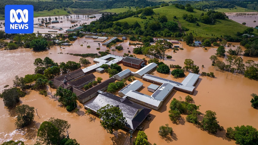
Under February 2022 flood conditions, the scenario that includes 10 detention basins at natural choke points in all river tributaries upstream of Casino and Lismore would reduce flooding in Lismore by 2.07 metres.
A mitigation scenario tested by the CSIRO includes “detention” dams, a second river outlet and restoration of the Tuckean Swamp (Supplied: CSIRO)
That record-breaking flood saw water overtop the Lismore levee at 10.2 metres and reach a height in the CBD of 14.37 metres.
The same mitigation scenario would see flooding reduced in Kyogle by 0.80 metres, in Casino by 0.95 metres, in Coraki by 0.42 metres and in Ballina by 0.73 metres.
Dr Vaze said this meant that even if the full suite of mitigation measures were built, flooding on a par with 2022 would still inundate townships in the catchment, but water levels would be reduced, the duration lessened and the footprint would be less widespread.
Hydrologist Dr Jai Vaze is the lead scientist on the CSIRO project. (ABC News)
“This has always been envisioned by the National Emergency Management Emergency (NEMA) as a pilot project, and the lessons … can become a guiding light for even large international flood mitigation projects,” he said.
The $11.4 million project is a hydrodynamic study and does not include the technical, environmental, economic and social feasibility of the mitigation measures.
Today the NSW and Federal governments committed a further $3 million to assess these matters.
Mitigation could reduce the level of flooding seen in Lismore in 2022 by 2.07 metres (ABC News)
Lismore MP and Disaster Recovery Minister Janelle Saffin said the report was a milestone for people living and working in the catchment.
“The next step is, OK, how do we approach this across four local government areas… the whole Richmond River catchment?” she said.
“This gives us real hope because it shows technically that flood levels can be lowered.”
The cost of the mitigation projects was not within the scope of the CSIRO’s work, and the cost-benefit analysis and business case is yet to be done.
In a statement, NEMA said it “remained committed to flood mitigation outcomes in the Northern Rivers”.
Federal MP Kevin Hogan, whose electorate of Page sits within the catchment, has urged governments to support mitigation.
“I remind everyone that if this was to cost around $2 billion-ish [for mitigation], that the 2022 event alone was a $15 billion damages bill,” he said.
Page MP Kevin Hogan is calling for mitigation projects to be funded (ABC North Coast: Bruce Mackenzie)
“That’s with taxpayer grants, with insurance losses, with the road network itself which cost billions of dollars.
“This investment in prevention will pay for itself 100-fold over the floods that will be avoided in the future.”
Leycester Creek is one of several tributaries that flow into the Wilsons River at Lismore (ABC North Coast Hannah Ross)
The report lists the exact latitude and longitude of the 10 detentions included in the CSIRO’s testing, as well as the water-holding capacity of each basin, and how the sluice gates would operate to hold and slowly release floodwater.
Rock Valley on Leycester Creek north west of Lismore has been identified in both mitigation scenarios as the site of a detention that would hold 93.4 gigalitres of water.
That would require a wall height from the bottom of the stream of 39 metres and a width from bank to bank of 389 metres.
Rock Valley residents Shane Doepel and Renata Phelps are keen for more information on where a dam would be located in their valley.
(ABC North Coast: Hannah Ross)
Local community resilience team member Shane Doepel said she doubted whether the project would be supported by the local community.
“I think even considering the idea seems pretty out of touch,” she said.
“Just thinking about building such a huge engineering structure, how it would affect the farmland and the community, I can’t see how that would be a positive.”
The modelling includes cutting a secondary outlet from the Richmond River to the sea at Boundary Creek. (ABC North Coast: Hannah Ross)
In the mid-Richmond, the mitigation modelling includes restoration of the Tuckean Swamp, a 6,000-hectare wetland upstream of Ballina, and opening Boundary Creek to the ocean through about 800 metres of cane and coastal plain, using a pressure gate to allow floodwater out but stop salt water flowing into the river.
Local landholder Dave Dorey said if the channel cut through his property he would feel “like Darryl Kerrigan from The Castle”.
“You wouldn’t want to stand in the road of a project that could help so many people and reduce the flood risk,” he said.
Three generations of David Dorey’s family have lived at Boundary Creek where the Richmond River runs closest to the sea. (ABC North Coast: Hannah Ross)
“At the same time, this farm’s got a lot of sentimental value, being my grandfather’s and now my kids here.”
NEMA and the CSIRO will be holding community drop-in sessions in the Northern Rivers in coming weeks to answer questions about the report.