






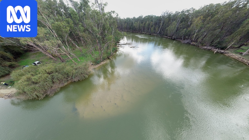
Australia’s largest river red gum forest along the mighty Murray is enjoying the spoils of winter floods, attracting more than 50 waterbird species in their thousands come spring.
It is a natural flood plain at the right time of year, but too much water out of season causes environmental havoc.
A massive accumulation of sand has exacerbated a bottleneck and restricted irrigation flows.
The sand slug, which was discovered at the Barmah narrows in 2019, was caused mainly by historic mining practices.
As the Murray Darling Basin Authority (MDBA) finalises its advice on what to do about it, some stakeholders say a shared desire to fix the problem is not enough for a river under high stress.
The Barmah forest is home to a variety of wildlife. (ABC News: Alice Walker)
Too much sand
Working out what to do about the stubborn sand slug is no easy task.
The amount of sand clogging up the river from Yarrawonga to Barmah would fill the Melbourne Cricket Ground 13 times.
MDBA director of environmental assets Natalie Dando said the narrows were acting like an hourglass, with sand moving in faster than it could get out.
“And the less water we can move through here, the more challenges there are for meeting the downstream demands of customers that need water for communities, for industry and the like,” Ms Dando said.
Natalie Dando says the sand will keep accumulating, decreasing river flows for “decades and decades”. (ABC News: Alice Walker)
The MDBA is due to present its advice on the issue to federal and state governments later this year, including regulatory processes, cost, and how to manage potential works in an area that is often flooded.
While Ms Dando was yet to reveal the authority’s preferred course of action, she said there were various issues considered.
“Where could we get access, where could we put material [sand], is there interest in that material once it’s removed, could it be useful for a commercial enterprise?” Ms Dando said.
Loading…
“I think the preferred solution will be the one that has the least impact.
“It’s the one that stakeholders can get behind because it’s the best solution that we can find in a really constrained environment.”
Flooding causes erosion, advantages invasive plants and impacts cultural sites. (ABC News: Alice Walker)
Process ‘hamstrung’
Bangerang Aboriginal Corporation has been consulting with the MDBA, but treaty manager Casey Atkinson said the process had been “hamstrung” by the contested nature of water management.
“People who don’t have the funding would like to do the work, people who have the funding can’t do the work because other people who have access or say in that land … don’t necessarily agree,” the Bangerang and Wiradjuri man said.
“So there’s a lot of different vested interests that converge.”
Mr Atkinson said the issue was affecting the whole community.
Casey Atkinson says he noticed sand shifting over decades around Cummeragunja Mission near Barmah. (ABC News: Alice Walker)
“We’re happy and open to working with the council and any other vested interests in trying to find shared common ground,” he said.
“But something has to be done because by the time it’s too late, you can cry about it but there’s nothing to do to change it.“
Losing the banks
Jodie Hay is an irrigation dairy and beef farmer who has transformed part of her property into wetlands at Cohuna.
She and her husband had been changing their processes in the past 30 years to reduce water use as allocations and pricing became less reliable.
Jodie Hay says the Murray River has been “over-allocated”. (Supplied: Annette Ruzichika)
She said she believed erosion caused by high irrigation demand downstream was a more likely cause of the sand slug.
“The bank erosion on our [stretch of the] river is hideous, just because of the high river flows, we’ve sort of lost anywhere between six and 10 metres since the Murray Darling Basin plan was implemented [from 2012],” she said.
“It’s quite heartbreaking really … the amount of big trees falling in is mad.“
Limited options
Fluvial geomorphologist and Professorial Fellow at the University of Melbourne, Ian Rutherford, was engaged as a consultant by the MDBA to study the source of the sand slug.
Eroded Murray River banks downstream of Barmah, near the junction with the Goulburn River. (Supplied: Alluvium Consulting)
He agreed irrigation flows had caused high levels of erosion, but said there was not enough to account for the 20 million cubic metres of sand, which stretched from Yarrawonga to Barmah.
“We’ve done the numbers on that and probably only about 10 per cent of the volume could come from bank erosion,” he said.
“I think the first issue to overcome is to recognise that there isn’t a simple solution, that this isn’t really anybody’s fault, this is not a conspiracy of government or anything like that. This is a legacy effect of past land uses.”
He said the sand slug was accelerating a natural constriction process at the narrow flood plain and solutions were limited.
Ian Rutherford says the sand slug must have passed Yarrawonga before the installation of the weir in the 1930s. (Supplied: Ian Rutherford)
“I think the irrigation solution seems to be pretty clear: moving water around the obstacle,” he said.
“The environmental challenges in the Barmah forest have always been pretty difficult because they [water managers] run the river so long and so hard.
“While they continue to do that, it’s probably challenging to do much about the problems we’re seeing at the moment.“
Moira Shire Council declined to comment.